

Fresno California Drone Service Company
Twilight Drones services all of Ohio for Aerial photography. We offer Aerial Photography for real estate , special events, and many other applications. Also we offer survey and inspection services. All our Pilots are FFA Part 107 commercial…
Drone 360 Vision are based in Sheffield, and work across the Yorkshire region or further if required. We are an innovate drone operating company who aim to provide our clients with the best service possible by utilizing the most recent in drone…
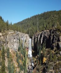
L7 Drone Services LLC… your go-to professional aerial photographers for Central Oregon. L7 Drone Services provides commercially licensed and insured pilots for aerial photography and videography in Central Oregon. Specifically, we shoot videos for…